
Digging Deeper: Why Purdue’s Radar Tech Isn’t Just About Avoiding Broken Pipes
We’re told the future is smart cities, digital twins, seamless infrastructure. But the foundation of all that – literally – is what’s under our feet. And right now, we’re remarkably bad at knowing what’s there. The Purdue University announcement of a patent-pending radar technology to locate underground pipes isn’t a story about incremental improvement in construction; it’s a stark reminder of how analog our understanding of the digital world’s support system remains. The real story here isn’t just preventing accidental dig-ins – it’s about the escalating cost of ignoring the hidden infrastructure that keeps modern life functioning.
See the original purdue.edu story for the full account.
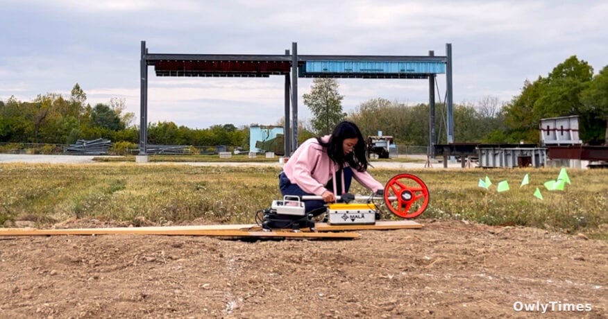
Hubo Cai, a professor at Purdue’s Lyles School of Civil and Construction Engineering, and doctoral candidate Yuxi Zhang have developed a method to refine ground-penetrating radar (GPR) data, moving beyond simply detecting pipes to estimating their location, orientation, and radius with quantified uncertainty. Traditional GPR, as Cai explains, identifies pipes by analyzing electromagnetic wave reflections. The problem? Real-world data is messy. Inherent uncertainties and data quality issues often lead to inaccurate mapping. Their solution, published in the January 2026 issue of Advanced Engineering Informatics, employs a Bayesian framework to create a “buffer zone” around estimated pipe locations, acknowledging the inherent imprecision.
This isn’t a theoretical exercise. The Common Ground Alliance estimated in 2019 that damage to underground infrastructure costs the US roughly $30 billion annually. While that number hasn’t been updated recently, consider the context: infrastructure spending is soaring, and construction activity is ramping up to support everything from broadband deployment to renewable energy projects. According to the 2022 Damage Information Reporting Tool, a staggering 87.84% of these incidents stem from inaccurate location information. That’s not just about money; it’s about service disruptions, potential injuries, and even fatalities. A slightly more accurate map isn’t just a convenience – it’s a public safety issue.
The technical details are impressive. Cai and Zhang’s forward model, used to predict electromagnetic wave travel times, achieved a root mean square error (RMSE) of 0.454 ns against high-fidelity simulations. More importantly, their Variational Inference and Markov Chain Monte Carlo (VI+MCMC) approach yielded 97.5% coverage rates on simulated data and 77.5% on field data, demonstrating the framework’s reliability. But translating those numbers into real-world impact requires understanding the current state of utility mapping. Currently, much of it relies on outdated paper records, incomplete as-built drawings, and a frustrating reliance on “call before you dig” systems that are only as good as the information they contain.
This is where the “digital twin” concept comes into play. Zhang frames the technology as a crucial first step toward creating a comprehensive digital representation of underground infrastructure. But a digital twin isn’t just a fancy 3D model; it’s a dynamic, constantly updated system that requires continuous data collection and analysis. Purdue’s technology offers a significant improvement in data quality, but it doesn’t solve the problem of data integration. Getting this information into a usable format, accessible to all stakeholders – from construction crews to utility companies – remains a massive challenge. The Purdue Innovates Office of Technology Commercialization is actively seeking industry partners to develop and commercialize the algorithm, a necessary step, but not a guarantee of widespread adoption.
The National Science Foundation funded this work, highlighting the public interest in improving infrastructure resilience. However, the ultimate success of this technology will depend on whether private companies see a clear return on investment. Will construction firms prioritize upfront costs for more accurate mapping, or will they continue to rely on cheaper, riskier methods? Will utility companies share their data to create a more comprehensive national map, or will proprietary concerns hinder collaboration? These are the questions that will determine whether Purdue’s innovation becomes a game-changer or another promising technology that languishes in the lab.
Looking ahead, expect to see a surge in demand for “digital excavation” technologies – tools that combine radar data with AI-powered analytics to provide real-time insights to construction crews. But more importantly, watch for a shift in liability. As the accuracy of mapping technology improves, the legal burden will increasingly fall on those who don’t utilize it. In 2028, I predict we’ll see the first major lawsuit where a construction company is held liable for damages specifically because they failed to employ available, advanced utility mapping technology. That’s when the conversation will truly change.