
For centuries, humans have relied on rivers – for sustenance, transportation, and as the lifeblood of civilizations. Yet, until very recently, our understanding of how these vital systems function on a global scale has been frustratingly incomplete. We’ve meticulously studied individual rivers, of course, but a comprehensive, continuous picture of river dynamics across the planet remained elusive. That’s beginning to change, thanks to the Surface Water and Ocean Topography (SWOT) mission, a collaborative effort between NASA/JPL and the Centre National d'Études Spatiales (CNES), with crucial contributions from the Canadian Space Agency and the United Kingdom Space Agency. The initial data release isn’t simply confirming what we already knew about rivers; it’s revealing a level of complexity and interconnectedness that demands a reassessment of how we manage and protect these resources.
A New Perspective on Global Waterways
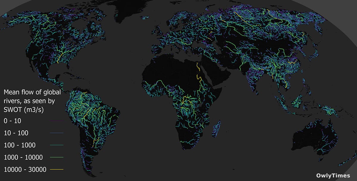
The core innovation of SWOT lies in its ability to measure river heights and widths continuously and globally. Previous methods relied heavily on ground-based gauges, which are sparse, particularly in remote regions, or infrequent satellite observations offering snapshots rather than a flowing record. SWOT employs a unique radar interferometer, essentially creating a “comb” of radar pulses that sweep across a river’s surface. This allows scientists to determine the water’s elevation with unprecedented accuracy – down to a few centimeters – and map the river’s cross-section. This isn’t just about knowing how much water is flowing; it’s about understanding where that water is, and how that distribution changes over time. Initial observations, encompassing rivers from the Mississippi to the Amazon, are already challenging existing hydrological models. For example, early data suggests that many rivers exhibit significantly more variability in their width and depth than previously estimated, particularly during flood events.
Beyond Volume: Unveiling River Behavior
The implications extend far beyond simply refining flow rate calculations. Understanding a river’s geometry – its width, depth, and the slope of its banks – is critical for predicting how it will respond to changes in rainfall, snowmelt, or human intervention. Consider the Amazon River, a system whose discharge accounts for roughly 20% of all freshwater entering the world’s oceans. Accurate SWOT data will allow researchers to better model the impact of deforestation on river flow, sediment transport, and the overall health of the Amazon rainforest ecosystem. Similarly, in the Mississippi River basin, where agricultural runoff and levee systems heavily influence water flow, SWOT observations can help assess the effectiveness of flood control measures and predict the impact of climate change on water availability. It’s important to note, however, that headlines proclaiming SWOT will “solve” water management problems are premature. The mission provides data; interpreting that data and translating it into actionable policies requires ongoing research and collaboration.
Reporting from [science.nasa.gov](https://science.nasa.gov/earth/swot-mission-unlocks-a-new-view-of-our-waterways/) informs this analysis.
What the Data Doesn’t Tell Us – Yet
While the initial data release is groundbreaking, it’s crucial to acknowledge the limitations. SWOT’s radar signal can be affected by vegetation overhanging the riverbanks, potentially introducing errors in width measurements, especially in densely forested areas. Furthermore, the mission’s current resolution may not be sufficient to accurately measure very small rivers or narrow channels. The data also doesn’t directly address water quality parameters like pollution levels or sediment composition – these require complementary monitoring efforts. A common misconception arising from early reports is that SWOT provides a complete picture of groundwater interactions with rivers. While the mission can detect changes in river height that suggest groundwater influence, it cannot directly measure subsurface flows. This is a critical distinction, as groundwater often plays a significant role in sustaining river flow during dry periods.
The Future of River Monitoring and Management
The next phase of the SWOT mission involves refining data processing algorithms, expanding the geographic coverage of observations, and integrating SWOT data with other datasets, such as precipitation records and land use maps. Researchers are also developing new models to better interpret the complex relationships between river geometry, flow dynamics, and ecosystem health. A particularly promising area of research is the use of SWOT data to improve flood forecasting accuracy. Current flood prediction models often rely on simplified representations of river channels, leading to uncertainties in predicting flood extent and timing. By incorporating SWOT’s high-resolution measurements, these models can be significantly improved, potentially saving lives and reducing economic damage. Looking ahead, we should anticipate a shift in how water resource managers approach river monitoring. Instead of relying on scattered point measurements, they will have access to a continuous, global view of river dynamics, enabling more informed and proactive decision-making. The key question now isn’t if we can better manage our rivers, but how we will translate this unprecedented wealth of data into effective and equitable water policies for all.