
Is the future of environmental monitoring less about building specialized satellites and more about squeezing hidden talents out of the ones we already have? NASA’s new PACE satellite, initially designed to study ocean ecosystems, is now unexpectedly tracking air pollution with surprising precision. The real story here isn't just about a new tool for environmental scientists – it’s about a quiet revolution in how we approach Earth observation, and what that means for the average person breathing the air in cities increasingly choked by emissions.
From Phytoplankton to Pollution: A Satellite’s Unexpected Skillset
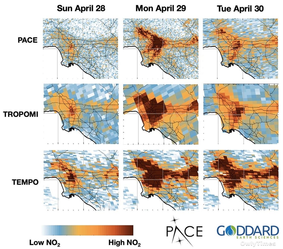
The Plankton, Aerosol, Cloud, ocean Ecosystem (PACE) satellite launched earlier this year with a clear mission: to analyze the world’s oceans, focusing on phytoplankton and atmospheric particles. Its core instrument, the Ocean Color Instrument (OCI), is a sophisticated sensor capable of measuring a continuous spectrum of light, from ultraviolet to near-infrared. This allows scientists to identify different substances based on their unique “spectral fingerprint” – how they reflect light. While initially focused on marine life, researchers realized that nitrogen dioxide, a harmful pollutant created by burning fossil fuels, also has a distinct spectral signature. It was a bit like discovering your family minivan can secretly do donuts.
Original reporting: science.nasa.gov.
This isn’t to say PACE was haphazardly repurposed. The key was leveraging data from the Tropospheric Monitoring Instrument (TROPOMI), already aboard the European Space Agency’s Sentinel-5P satellite. TROPOMI excels at measuring nitrogen dioxide, but its resolution – the level of detail it can capture – is relatively coarse. Think of it as a blurry photograph. PACE’s OCI, however, offers a much sharper image. By using TROPOMI data to “train” PACE, scientists essentially taught the ocean-focused satellite to identify and measure nitrogen dioxide with unprecedented accuracy, pinpointing sources as small as a single factory or even pollution plumes from busy highway corridors.
The Resolution Revolution: Why Granular Data Matters
For years, air quality monitoring relied on ground-based sensors, which are expensive to maintain and can’t cover vast areas. Existing satellite data, like that from TROPOMI, provided a broader overview but lacked the granularity needed for targeted interventions. This new PACE capability changes that. The ability to identify specific emission sources isn’t just an academic exercise. It has direct implications for public health, allowing cities to focus mitigation efforts on the most problematic areas. Consider the implications for communities living near major roadways or industrial facilities – they could finally have the data needed to demand accountability and cleaner air.
The potential impact extends beyond urban centers. Dr. Erica McNamee, who led the development of this new data product, highlighted the benefits for agricultural productivity, suggesting that targeted pollution reduction could protect crops from ozone damage. But let’s be clear: this isn’t a magic bullet. The data is now available on NASA Earthdata, but translating that data into policy changes and tangible improvements in air quality will require sustained effort and political will. A sharper picture of the problem doesn’t automatically solve it.
Beyond Nitrogen Dioxide: The Future of Multi-Purpose Satellites
The success of repurposing PACE raises a crucial question: are we over-investing in single-purpose satellites when existing platforms have untapped potential? Building and launching a satellite costs billions of dollars and takes years. The current model often prioritizes narrowly defined scientific objectives, potentially overlooking opportunities for synergy and cost-effectiveness. PACE’s unexpected ability to monitor nitrogen dioxide demonstrates that we can get more mileage out of our existing orbital infrastructure.
This isn’t about abandoning specialized missions, but about embracing a more holistic approach to Earth observation. What other “hidden talents” might be lurking within the data streams of existing satellites? Could we adapt instruments designed to monitor cloud cover to track methane leaks, or repurpose sensors focused on land use to detect illegal deforestation? The real opportunity lies in fostering a culture of innovation that encourages scientists to think beyond the original design parameters of these complex machines.
Looking ahead, I predict that within the next three years, we’ll see a significant increase in “satellite hacking” – not in the malicious sense, but in the creative repurposing of existing instruments to address emerging environmental challenges. The question isn’t if satellites can do more, but how quickly we can unlock their full potential, and whether regulatory frameworks will keep pace with this rapidly evolving landscape.