
The familiar ochre haze descending upon the Canary Islands in late March and early April 2026 isn’t a novel phenomenon, but the scale of the recent event – documented in striking detail by NASA’s Terra and NOAA-21 satellites, alongside observations from EUMETSAT’s Meteosat-12 – underscores a growing need to understand not just when these Saharan dust storms occur, but why they are intensifying and becoming more frequent. While headlines focused on disrupted travel and reduced visibility, the story is less about an isolated weather event and more about a complex interplay of atmospheric conditions and long-term environmental shifts that are reshaping dust mobilization across North Africa. It’s a story of wind, geography, and a climate system sending increasingly visible signals.
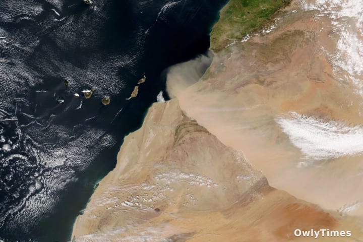
The event, triggered by a dry, dust-laden wind known as the harmattan, began sweeping across northwestern Africa in early spring. On March 30th, satellites tracked a substantial wall of dust moving southwest from the Sahara Desert towards the Atlantic Ocean and, crucially, the Canary Islands. Images captured throughout the day reveal the progression of the storm, with the Terra satellite providing a snapshot at 10:00 Universal Time, followed by NOAA-21 four hours later. Spain’s state meteorological agency, AEMET, identified the conditions as ripe for a “harmattan surge,” a strengthening of the winds as a cold front passed through, converging perpendicularly with the High Atlas mountain range before shifting southwest. This isn’t simply a case of wind picking up sand; it’s a specific meteorological setup that maximizes dust lifting potential. The resulting “calima,” as islanders call it, brought not only reduced visibility but also a documented decline in air quality, a concern that extended beyond the islands given a similar, though less intense, dust plume reached Europe earlier in March.
Source material: science.nasa.gov.
What’s often presented as a seasonal nuisance is, in fact, a significant atmospheric process. Researchers, including those utilizing NASA data, have long known that the most intense Saharan dust storms typically occur in the spring, originating from the sand seas – or ergs – of central North Africa and areas along the Mediterranean coast. A secondary peak occurs in the warmer months within the central Sahara. However, the increasing frequency and intensity of these events, as evidenced by the back-to-back plumes in March 2026, are prompting a re-evaluation of the factors driving dust mobilization. A 2015 study by Fiedler et al. in Geophysical Research Letters highlighted the importance of Harmattan surges in dust emission, but the current situation suggests these surges may be becoming more powerful or occurring more often. Preliminary assessments, like that conducted by Saleh et al. in Scientific African (2025), are beginning to map the spatial and temporal patterns of these storms, but a comprehensive understanding of the underlying causes remains elusive.
It’s important to clarify what the data actually shows. Reports emphasize the impact on the Canary Islands – and rightly so, given the disruption to daily life – but the broader picture reveals a complex system. The dust isn’t simply “arriving” at the islands; it’s being transported across vast distances, impacting air quality and potentially influencing climate patterns far beyond the immediate region. The focus on the “calima” effect, while locally relevant, can overshadow the larger-scale implications of increased Saharan dust transport. Furthermore, while the harmattan winds are a known seasonal driver, the intensity of the March 2026 event suggests additional factors are at play, potentially linked to broader climate variability or land-use changes within the Sahara itself. Morocco issued an orange alert for cold weather, strong winds, and dust storms on March 30th, demonstrating the immediate regional impact, but the story doesn’t end at national borders.
Limitations to consider include the reliance on satellite data, which provides a broad overview but lacks the granular detail of ground-based measurements. While NASA’s and EUMETSAT’s instruments offer invaluable insights, they cannot fully capture the complex interactions between wind, topography, and surface conditions that govern dust mobilization. Additionally, attributing specific events solely to climate change is premature; natural variability plays a significant role. However, the observed trends – increased frequency and intensity – warrant further investigation into the potential influence of human-induced climate shifts on atmospheric circulation patterns and land surface characteristics.
The next crucial research steps involve integrating satellite observations with ground-based monitoring networks across North Africa to create a more comprehensive picture of dust emission sources and transport pathways. Furthermore, climate models need to be refined to accurately simulate the complex interactions between atmospheric dynamics, land surface processes, and dust mobilization. Specifically, researchers need to determine whether the observed increase in harmattan surge intensity is a temporary fluctuation or a sustained trend, and whether this trend is linked to changes in sea surface temperatures, atmospheric pressure gradients, or land degradation within the Sahara. The question isn’t just if these dust storms will continue, but how their characteristics will evolve, and what that means for air quality, climate, and the communities directly impacted by these increasingly frequent and intense events. Will we see a future where “calima” becomes the new normal for the Canary Islands, and Saharan dust a more regular feature of European skies?