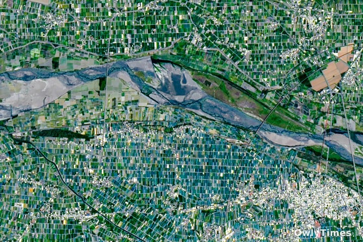

How can a landmass roughly the size of Maryland, much of which is dominated by rugged mountains, sustain a population of 23 million people while generating $18 billion in agricultural output annually? This question sits at the intersection of geography, historical policy, and modern innovation. Recent satellite imagery from the NASA Earth Observatory dated April 24, 2026, provides a striking visual answer, highlighting the intense, patchwork cultivation defining Yunlin County in southwestern Taiwan.
The Geography of Scarcity and Efficiency
When we examine the data, the scale of Taiwan’s agricultural feat becomes clear. Only about one-quarter of the island’s total land area is considered arable, concentrated largely in the Chianan Plain. This results in just 0.03 hectares of farmland per citizen. To provide context, this is approximately half the arable land per person found in the United Kingdom and a mere one-tenth of the availability in the United States.
The scientific reality revealed by this imagery is a landscape of extreme fragmentation. The average Taiwanese farm spans less than 1 hectare, a stark contrast to the 87 hectares typical in the U.K. or the 187 hectares in the U.S. This small-plot reality is not an accident of nature; it is a byproduct of cultural inheritance practices—where land is divided among heirs over generations—and historical land-use policies.
Colonial Legacies in the Modern Field
What the satellite imagery captures versus what a casual observer might assume is a primary tension between modern usage and historical infrastructure. While the majority of Yunlin’s fields are small, rectangular plots defined by irrigation canals, the area north of Baozhong presents an outlier: significantly larger fields.
These larger plots are a direct, persistent legacy of the early 1900s, when Japan established an expansive network of sugarcane plantations. After the conclusion of World War II, these lands were consolidated into the Taiwan Sugar Corporation. While the island has transitioned away from the widespread sugar cultivation of the colonial era, this corporation remains a major player, operating the island’s last active sugar railway that services the refinery in Huwei. This serves as a rare, tangible piece of industrial history still functioning within a modern agricultural economy.
Limitations to Consider
It is important to note that while high-resolution satellite data offers a precise view of surface-level patterns, it cannot fully capture the internal socioeconomic pressures of these farming communities. The imagery clearly distinguishes crops, such as the greenish-blue hue of fields in Xiluo protected by shade nets against pests and heat, from the darker green of rice paddies. However, these visualizations do not show the economic viability or the labor intensity required to manage such small, high-yield parcels. The reliance on intensive technology—like shade netting and specialized irrigation—is a necessary response to the scarcity of land, but the sustainability of this model as property continues to fragment remains a subject of ongoing inquiry.
Future Research and Monitoring
The next steps in understanding this region involve looking closer at the intersection of precision agriculture and land-cover change. Researchers are increasingly using remote sensing, such as Sentinel-1 time series data, to track how these crops shift across the landscape in response to climate pressures and market demands. The future of Taiwan’s food security will be found in the next reading of land-cover transformation metrics, which will reveal whether the current agricultural density can hold steady as generational transitions and environmental factors continue to challenge the limits of the Chianan Plain.