
When we consider the violent geologic forces shaping our planet, we often envision the fiery, molten rivers of traditional volcanoes. Yet, beneath the waters of the Caspian Sea and across the landscape of Azerbaijan, a different, colder, and arguably more volatile process is at work. The recent satellite imagery released by the NASA Earth Observatory on April 21, 2026, highlights a series of tadpole-shaped islands off the Absheron Peninsula, serving as a stark reminder that the Earth’s crust is a dynamic, shifting mosaic.
These structures are not islands in the traditional sense, but the exposed tops of massive mud volcanoes. While the public often equates volcanoes with heat and lava, these formations operate through a complex interplay of pressure and hydrocarbon accumulation. Sedimentary basins in this region trap oil, water, and methane under intense pressure. When this mixture finds a path to the surface through structural faults, it erupts as a cold slurry of mud and gas.
The Geologic Engine of the Caucasus
Azerbaijan is a global epicenter for this phenomenon, hosting at least 220 mud volcanoes according to government data, though some researchers estimate the total could reach 350. This concentration is largely due to the unique tectonic conditions of the South Caspian Basin. The region is rich in hydrocarbons—the remnants of ancient marine organisms—which, when subjected to extreme heat and pressure over millennia, provide the fuel for these intermittent, often explosive events.
On land, these volcanoes create conical structures that can reach impressive dimensions, ranging from 20 to 400 meters in height and spanning up to 4,500 meters in diameter. However, it is the underwater activity that is currently capturing scientific interest. There are at least 140 known underwater mud volcanoes along the Azerbaijani coast, including those forming the Baku archipelago.
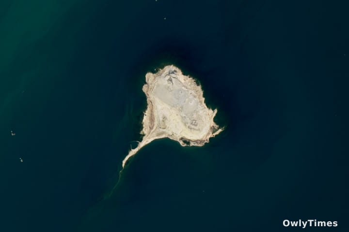
Interpreting the "Tadpole" Morphology
The striking "tails" seen on islands like Xərə Zirə Adası—also known as Ostrov Bulla—might appear to be remnants of lava flows, but they are actually a product of erosion. Adelaide University geologist Mark Tingay notes that these features are created by the interaction of currents and the island’s soft, unconsolidated mud deposits. Essentially, wave action and currents redistribute the sediment on the "lee" side of the island, carving the distinct, elongated shapes captured by satellite sensors.
While the imagery presents a serene view of these islands, the reality of their formation is far from calm. Xərə Zirə Adası experienced significant, violent eruptions in 1961 and 1995. Similarly, the nearby island of Duvannı (Ostrov Duvannyy) saw an eruption as recently as 2006. These events are not merely geological curiosities; they represent the sudden release of immense subsurface energy.
The Unpredictable Nature of Paroxysmal Eruptions
It is important to distinguish between the steady "weakly active" venting observed today and the potential for "paroxysmal eruptions." As Tingay explains, these mud volcanoes are capable of short, violent outbursts that can produce fireballs and even spawn entirely new islands in a matter of minutes. The history of Səngi Muğan Adası (Ostrov Svinoy) provides a sobering example; a 1932 eruption there produced a 150-meter-tall fireball that injured 13 people and nearly destroyed a lighthouse.
Limitations to consider include the difficulty of predicting such events. While these volcanoes serve as useful indicators for underground fossil fuel deposits, their internal plumbing is complex and largely inaccessible to real-time monitoring. We are currently observing a snapshot of a highly dynamic system, and while the current satellite data helps us understand the morphological evolution of these islands, it cannot yet forecast the timing of the next major eruptive cycle.
Looking ahead, the focus of the geological community remains on the South Caspian Basin. Researchers are closely monitoring the active vents on islands like Duvannı and Səngi Muğan Adası. Future analysis of these specific vents will indicate whether the current pattern of "weak" activity is a precursor to larger subterranean shifts or merely a standard phase of the region’s ongoing geologic respiration.